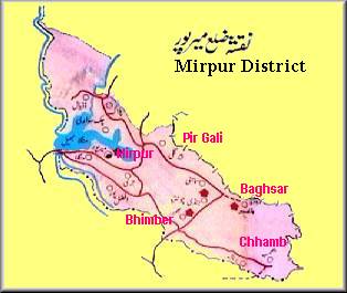
Mirpur district comprises partly plain and partly hilly areas. Its hot
climate and other geographical conditions closely resemble those of Jhelum
and Gujrat, the adjoining districts of Pakistan. The people of this area are
basically farmers. Since the 1960s, a large number of people from this
district have gone abroad , especially to the United Kingdom and the Middle
East, for economic reasons. As such they are today the major foreign
exchange earning source for Azad Kashmir and Pakistan. Around 50,000 people
were moved from this district in the mid-sixties to make way for the
construction of Mangla Dam. Most of these people settled in new Mirpur
whilst some moved to Pakistan and the UK.
Mirpur city is situated at 459m above sea-level and is linked with
the main Peshawar-Lahore Grand Trunk road at Dina. The building of the new
city in late sixties paved the way for new Mirpur situated on the banks of
Mangla lake. The city was well planned and the buildings are mostly of
modern design. Mirpur is developing into an industrial city very rapidly.
Textile, vegetable ghee, logging and sawmills, soap, cosmetics, marble,
ready-made garments, matches, rosin, turpentine and Vespa scooter industrial
units have already been established in the area.
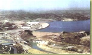
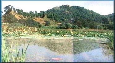
Mangla is a small but beautiful modern town situated 16Km from
Mirpur at the mouth of the Mangla Dam.The construction of the Dam reservoir,
which has a perimeter of 400Km, has turned it into a place of interest. A
castle situated on the lake-side serves as a historical back-drop.
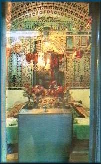 Located
8Km from Mirpur is Khari Sharif. Known for housing the Shrine of the
Sufi Saint known as Baba Pir-e-Shah Ghazi (Damrian Wali Sarkar). The place
acts as a great seat of learning for students of Islam. Darvishs (disciples)
of the Saint can be seen today wandering in AJK and Pakistan. Also at Khari
Sharif is the Shrine of the late Mian Mohammed Baksh who wrote the famous
tale Saif-ul-Muluk. This tells of a Prince who fell in love with a fairy
called Badi Jamal who he saw in a dream. The story chronicals his travels in
search of the fairy and the spiritual lessons he learns on the way. Located
8Km from Mirpur is Khari Sharif. Known for housing the Shrine of the
Sufi Saint known as Baba Pir-e-Shah Ghazi (Damrian Wali Sarkar). The place
acts as a great seat of learning for students of Islam. Darvishs (disciples)
of the Saint can be seen today wandering in AJK and Pakistan. Also at Khari
Sharif is the Shrine of the late Mian Mohammed Baksh who wrote the famous
tale Saif-ul-Muluk. This tells of a Prince who fell in love with a fairy
called Badi Jamal who he saw in a dream. The story chronicals his travels in
search of the fairy and the spiritual lessons he learns on the way.
 Bhimber
is a sub-division (Thesil) of the district, situated 50Km from Mirpur. The
area is very rich in archaeological remains. Bhimber falls on on the route
that was followed by the Moghul rulers of India for their frequent visits to
the Kashmir Valley. Bhimber
is a sub-division (Thesil) of the district, situated 50Km from Mirpur. The
area is very rich in archaeological remains. Bhimber falls on on the route
that was followed by the Moghul rulers of India for their frequent visits to
the Kashmir Valley.
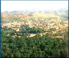
Jandi Chontra is a scenic spot located 17Km from Bhimber and 67Km from
Mirpur. The area is known for its panaromic views. The Shrine of the Sufi
Saint Baba Shadi Shaheed is also located here.
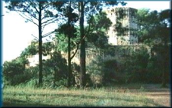 Baghsar
is situated at 975m above sea-level in the Samahni valley. The Sar, local
name for a lake, is nearly half kilometre long sheet of clear water that
soothes the senses of the visitor. On top of a hill is the famous Moghul
Fort over-looking the lake that adds grandeur to the area. This four storey
massive structure of granite is a feat of Mughal engineering that has stood
the ravages of time. It has also played important roles in history during
the times of Ahmed Shah Abdali, Ranjit Singh and Gulab Singh. It is said
that the Mughal Emperor Janghir, on his way back from the Kashmir Valley,
fell ill and ultimately died in this fort. Baghsar
is situated at 975m above sea-level in the Samahni valley. The Sar, local
name for a lake, is nearly half kilometre long sheet of clear water that
soothes the senses of the visitor. On top of a hill is the famous Moghul
Fort over-looking the lake that adds grandeur to the area. This four storey
massive structure of granite is a feat of Mughal engineering that has stood
the ravages of time. It has also played important roles in history during
the times of Ahmed Shah Abdali, Ranjit Singh and Gulab Singh. It is said
that the Mughal Emperor Janghir, on his way back from the Kashmir Valley,
fell ill and ultimately died in this fort.
|
